Responsibilities include development and administration of Teton County’s Subdivision Regulations, Hazard Mitigation Plan, enforcement of Floodplain Regulations, and overall land use management for the County in accordance with the Growth Policy. Our responsibilities also include facilitating communication between the landowners/developers and Stahly Engineering for the review of certificates of survey prior to filing with the County Clerk and Recorder for clerical errors and omissions and to ensure exempt divisions of land are in compliance with the provisions outlined in the Montana Subdivision and Planning Act. Our office also issues new rural addresses and develops project maps for other departments. All 911 address data is created, edited and disbursed to the appropriate agencies as necessary to facilitate emergency response. This office issues floodplain permits and letters to interested parties regarding the absence of zoning in the county, when requested.
Staff
Brian Colesworthy
Teton County Planner
Email: bcolesworthy@tetoncountymt.gov
19 Main Ave South
PO Box 610
Choteau, MT 59422
406-466-3130 office
406-750-6788 cell
Maps of Teton County
Follow this link to the Teton County ArcGIS web page with maps, apps and demographic/economic information about Teton County MT.
2023 Growth Policy Plan
New Address Form
Floodplain Re-mapping Updates and Data
https://dnrc.mt.gov/Water-Resources/Floodplains/Floodplain-Mapping-Updates/Teton-County-Flood-Maps-Update
https://dnrc.mt.gov/Water-Resources/Floodplains/
Information on Stream Gauges: http://tetonriver-mt.blogspot.com/
Montana State Library LiDAR Data https://mslservices.mt.gov/Geographic_Information/Data/DataList/datalist_Details.aspx?did={354b7afe-64b2-4d63-aa79-e6f8e01787d0}
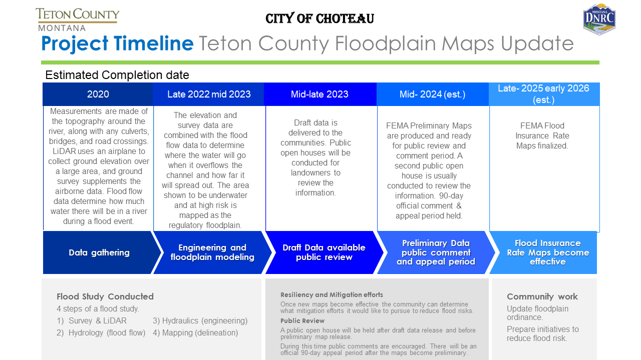
Teton County Floodplain Map Timeline 2023
Owning Property in Flood Plain 100yr Fact Sheet
Owning Property in Flood Plain 500yr Fact Sheet
Owning Property in Floodway Fact Sheet
10 Questions to ask your potential floodplain consultant
Change Your Flood Zone Designation | FEMA.gov
Flood Insurance Links and Resources
FloodSmart | Who Can Sell Flood Insurance? | FloodSmart – Agents
Flood Insurance | Montana Commissioner of Insurance (csimt.gov)
Risk Rating 2.0 Discounts Risk Rating 2.0 Discount Guide-508c
Risk Rating 2.0 Explanation Guide Risk Rating 2.0 Rate Explanation Guide
Floodplain Regulations
*Floodplain Permit Application Fee is $500*
*Floodplain Variance Permit Application Fee is $500*
July 2022 Floodplain Regulations
Permit Information: Permitting and Regulations (mt.gov)
Floodplain Variance Application
Subdivision Regulations/Forms